Ever wonder what the flight plan used by pilots looks like? Here is one from an Angel Flight on the day after Thanksgiving. I will explain the handwriting below.
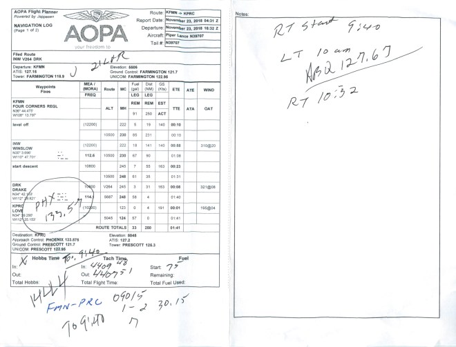
The printed material contains information about the two airports and lists the routing between the departure and the destination. The “J 21 L&R” written in at the top is the “ATIS” information at Prescott – ATIS information “Juliet” – the wind was calm, I put the altimeter in as I heard it, and they were landing Runways 21 L and 21 R.
“PHX 133.57” is Phoenix Approach and its frequency. It provides radar separation services, and I was switched there near PRC. “TO: 9:40” is the time I took off in FMN. “1444” is the transponder code I received when I contacted Denver Center for VFR flight following.
The notes to the right of the blue ink are the FMN ATIS information as I departed: Winds out of the East at 5 knots, Altimeter (barometric) setting 30.15 inches of mercury, and Runway 7 was in use. I forgot at first to note which letter the ATIS was designated. I listened again and the “X” by the Hobbs time on the form means it was information “X-Ray”.
On the Notes page, RT – right tank – which was the fuel tank in use on takeoff. LT – left tank – I switched to it at 10 a.m. I switched back to the right tank at 10:32. “ABQ 127.67” is Albuquerque Center and its frequency is 127.67. I was switched to ABQ Center just northeast of Winslow.
Back to the other page: The tach time is time reflected on the tachometer and represents “hours” the engine has run on a particular flight. We don’t measure things in miles in aviation, but either hours of use or “cycles”; for example, how many times a landing gear has been up and down or a hull pressurized in a pressurized airplane.
This one is neater than many. A hard IFR flight will have notes everywhere on the form. Now I am sure some of the engineering geeks out there have a perfect form for all of this, and write down everything very neatly, but we mere mortals want to record the information just long enough to tune the radio, set up the approach, or to know which runway to use. It is scribbled down, used, and on to the next item or issue.
This plan was kneeboard size, so it was folded in half with the printed page up for most of the trip, and the notes page used for things during which you may have a little more time. The ABQ frequency is on the notes page because the switch occurred while I was making a note regarding a tank switch.
So there you go! You are now ready to plan your own cross-country now that you know all the secrets!
Clear Skies and Tailwinds!
Gary Risley
RizAir Blog 7 12-22-2018
